

- November 6, 2019
- Posted by: Communications
- Categories: Biodiversity and Natural Resources in Bunyoro Kitara Kingdom, Resources, Study Corner
The Albertine Rift or Africa’s Western Rift Valley is one of the most biodiverse regions of the African continent. With more than half of Africa’s birds, 40% of Africa’s mammals and about 20% of its amphibians and plants, it contains more vertebrate species than anywhere else on the continent. It also conserves more threatened and endemic species than any other region of Africa, and as a result is a Biodiversity Hotspot, a Global 200 Ecoregion and an Endemic Bird Area
The Ugandan Rift Valley, the flat savannah between the western mountains and the eastern escarpment, is what is described as an ecoregion or biodiversity hotspot and has been recognised by UNESCO as a world bio-sphere reserve.
It supports more vertebrate species than any other part of Africa, including 1061 bird species (half of Africa’s total and including 41 endemic and 25 threatened species) and 402 mammals (34 of which are endemic). It boasts 175 reptiles, 16 of which are endemic. The Western Branch of the East African Rift Valley is what divides Uganda from DR Congo, and East African grasslands from the tropical forests of West Africa.
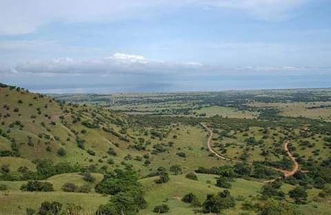
The journey through what is known – while it is in Uganda – as the Albertine Rift Valley, is an impressive one. The landscape changes from the grasslands and river estuary of Murchison Falls National Park in the north, to the wide plains of Semliki, then on to the Mountains of the Moon (Rwenzoris) described by Ptolemy, taking in lakes with strange Victorian names on the way: Lake Albert, Lake Edward and Lake George.
The lakes mark the places where plates have moved. Indeed, the whole area is dotted with crater lakes and still experiences periodic earthquakes, as we ourselves can lay witness to. The Virunga range to the south, part of DR Congo, still experiences volcanic eruptions, for instance quite recently in Goma.
Accessing the “Ekikonko kya Mwitanzige” or Albertine Rift Valley is enjoyable, you can use the breath taking Kyangwali Buhuka road alternatively you can use the 90 Km Kaiso Tonya road up to the Kaiso landing site, but to better enjoy the escarpments of the rift vally once is encouraged to take a walk down from Buseruka to the Kabalega Hyro Power Dam further once can access the Albertine rift valley from the short terrain route from Kigorobya to Kibiro Salt mines all these routes will be able to give you a full breath taking view of the well endowed rift valley.